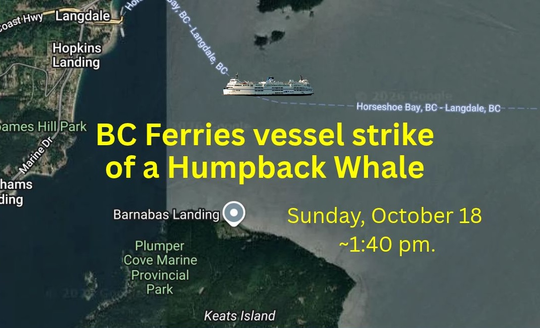
We have compiled the following as a backgrounder on what happened and how, hopefully, this collision can motivate reduced risk.
Known:
- Happened on Sunday, October 18 around 1:40 pm.
- The BC Ferries vessel was the Queen of Surrey, operating on the Langdale to Horseshoe Bay route.
- The collision happened near the Grace Islands, between Gambier and Keats Islands, off the Sunshine Coast.
- The ferry was travelling at 16 knots (30 km/hour).
- The collision was reported by BC Ferries to the DFO Incident Reporting Line (1-800-465-4336) as is national law for all vessels if there is accidental contact such as vessel strike and entanglement.
- Ways it could have been known that whales were in the area include use of the Whale Report Alert System, sightings from an earlier ferry sailing on this route, and the seasonal presence of Humpbacks in the area. This is the same general area of where Wisp (BCY1464) the Humpback Whale, was found dead from blunt force trauma after a Prince of Whales vessel collided with a Humpback on October 23rd, 2025.
- According to witness accounts from passengers on the ferry, the whale surfaced in front of the bow, travelling from right to left. The whale then surfaced behind the ferry, thrashing, with red visible in the water. Passenger accounts indicate that the ferry did not slow after the collision and that there was no communication to passengers about the impact they felt or what follow-up actions might be taken.
Questions:
Who is the Humpback? Unknown. The imagery members of the Canadian Pacific Humpback Collaboration have seen does not allow identification of which Humpback was struck.
Was the strike fatal? Likely due to the speed the vessel was travelling and how direct the hit is believed to have been. However, a fatality may never be confirmed because dead whales often sink to the ocean floor. The ferry was traveling at 16 knots when it hit the whale and video shows significant blood in the water (the whale surfaces, exhales, and then there is a spray of blood). Research (Kelley et al., 2021) puts forward that even collisions with smaller vessels (less than 20 m long) travelling at 10 knots can result in “significant probability of mortality”.
Was the vessel using the Whale Report Alert System? This is an important question. WRAS alerts verified large vessel operators to the presence of whales for the purpose of avoidance. The alerts result from whale sightings submitted to the WhaleReport app by members of the public and other mariners.
How to make this count:
Not unlike considerations in school crossing zones, the risk of collision can be decreased by decreasing the number, location, and/or speed of traffic in areas of known whale density. Reducing speed increases the potential to avoid a vessel strike and reduces the likelihood of a fatal outcome if a whale is hit.
May it highlight how essential it is to be educated about Humpback Whale behaviour and habitat use. Humpbacks do not have biosonar/echolocation like Orca.
To date, there is only one slowdown zone on the coast of British Columbia that considers baleen whales like Humpbacks. This is a voluntary slow down zone by BC Ferries in Wright Sound (Central Coast, Gitga’at Territory) resulting from collisions with Humpbacks in that area.
Development/confirmation of protocols for large vessel traffic: Is the Whale Report Alert System being used? How? What are the protocols if whales are known to be in the area? What are the protocols if a whale is hit?
There is promise in some technology for detecting whales but, in this case, whales are known to be in the area at this time of year. In fact, McMillan et al. (2025) found that Humpback numbers in the Salish Sea were highest from October to December. The limitations of technology must also be acknowledged. For example, infrared cameras can detect temperature differences associated with a whale’s blow or body. Limitations include weather and sea state, the time required to detect a whale relative to vessel speed, and the vessel’s ability to slow down and/or change course.
For the public:
The big picture is that we are all empowered to influence vessel presence, size, number, and behaviour on our coast. This includes advocating for slowdown and avoidance zones; influencing where and when high-speed and/or large vessels (including tankers and cargo ships) operate; how many there are; and the protocols they follow.
- Know how real the risk of vessel strike is and what it can mean for whale and boater safety, especially for those operating smaller vessels.
- Value how your energy use, voting and consumer choices, and ability to educate others can influence the risk of collisions with whales.
- Learn how to reduce the risk of vessel strikes and help educate others. Take the online Whale-Safe Boating course at www.WhaleSafeBoating.org.
The course includes information about:- Using the Whale Report Alert System to alert verified large vessel operators to the presence of whales for the purposes of avoidance.
- Reporting incidents of concern and being alert for signs of marine mammals in distress (e.g. from entanglement and collision).
- Submitting whale sighting data to improve understanding of habitat use and distribution.
- Using the Whale Warning Flag.
- Educating others, including about ethics and practices around social media use.
- Identifying coastal marine mammal species and understanding their behaviour.